




Airborne Magnetic Survey Generates 22 Priority Gold Exploration Targets

FREE Breaking News Alerts from StreetInsider.com!
StreetInsider.com Top Tickers, 10/27/2026
- Wall Street ends higher on revived AI momentum
- Meta's $97.5B AI money grab: why Zuckerberg is racing to raise cash before rivals
- Deutsche Bank’s Reid sees potential final dip this year before Santa rally
- UPS tops estimates as efficiency drive gains momentum
- GM to move stock listing to Nasdaq in November, shares gain
 Tweet
 Share
 E-mail
Phase I Exploration Program Completed
Marine Survey to Explore Priority Magnetic Targets
Toronto, Ontario--(Newsfile Corp. - October 27, 2026) - GoldCoast Resource Corp. (CSE: GCR) (OTC: GCRFF) (FSE: EKW) ("GoldCoast" or the "Company") is pleased to announce the results of the interpretation of its airborne magnetic survey flown over its 10,000 km² offshore licence area on Ghana's shallow continental shelf which has identified 22 significant magnetic anomalies that represent high-priority gold exploration targets associated with paleo-river channels, transgressive paleo-shorelines (reworked beach sands, or strandlines), and structurally controlled sediment traps, including basement ridges, paleo-scarps and basement lows.
Highlights
Survey completed: High-resolution airborne magnetic data has been acquired and interpreted over the Company's entire 10,000 km² licence area, on north-south flight lines at 400-meter spacing. The Survey was initiated May 04, 2026, and concluded on August 22, 2026. In total, approximately 60,000-line kilometers were flown.
Magnetic pathfinder minerals: The accumulation of magnetic heavy minerals such as magnetite can be detected by an airborne magnetic survey and their detection serve as a pathfinder for gold. The Company's completed survey has identified a total of 22 significant gold exploration targets across the Company's 10,000 km² licence area.
The following video provides a detailed explanation of GoldCoast's airborne magnetic survey.
Click link to watch: GoldCoast Resource Corp. Geophysical Aircraft Walkaround Video
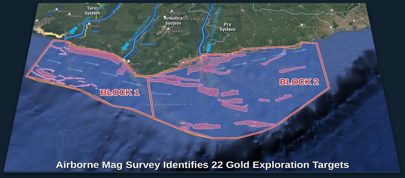
Figure 1: 22 gold exploration targets interpreted from the airborne magnetic survey across Blocks 1 and 2 of GoldCoast's 10,000 km² licence area. Target outlines are interpretive and shown schematically.
To view an enhanced version of this graphic, please visit:
https://images.newsfilecorp.com/files/12162/321295_6f5eff5d54fc080b_001full.jpg
Shore-parallel trap features resolved: The north-south flight lines optimally image features oriented parallel to the coastline, including interpreted transgressive paleo-shorelines (strandlines), paleo-scarps and basement ridges.
Two source-to-sink placer systems defined: The Tano-Ankobra system (Block 1) and the Pra River and eastern river systems (Block 2). In each Block, the interpretation identifies all four elements required for a placer gold deposit: a source of gold, a transport pathway, a trap where it can concentrate, and a reservoir of sediment where it can accumulate.
Paleo-shoreline target defined at the Pra River mouth: A belt of stepped Birimian bedrock terraces running parallel to the coast, interpreted as former shorelines (strandlines) drowned as sea level rose. Beach sands along such shorelines are a recognized setting for the concentration of gold and heavy minerals.
Paleo-drainage corridors identified: The interpreted former river courses extend across the inner shelf, most prominently offshore of the Pra River and the smaller rivers to the east.
East-west infill survey completed over Target A: Paleo-river channels (generally) running perpendicular to the coast and parallel to the regional north-south flight lines are less clearly resolved. The Company has therefore flown a second survey over Target A, an area of approximately 500 km² at the mouth of the Ankobra River, and the site of its initial prospecting licence application. This survey used east-west lines at 50-meter spacing, eight times denser than the regional survey, to cross the channels at right angles and improve their detection. This data is being interpreted, and results will be reported in a subsequent press release in Q4 2026. Similar infill surveys are planned over the Pra and Tano river mouths.
Interpretation to guide Phase II marine program: Multibeam bathymetry, side-scan sonar, sub-bottom seismic profiling and vibracore sampling will test the priority airborne magnetic targets.
Management Comment
Michael Nikiforuk, Founder, CEO and Director of GoldCoast, stated: "We are extremely pleased with the results of our airborne magnetic survey, as it has achieved our objective of delivering and substantiating a clear regional picture of priority gold exploration targets across our licence area that includes identifying all four elements needed for placer gold to accumulate offshore: a Source of gold, a Transport Pathway, Traps where it can concentrate, and Reservoirs where it can accumulate."
"GoldCoast was founded to test a very significant theory with far-reaching implications, put forward by one of our Founders, Dr. R. J. Griffis, senior author of the authoritative text "The Gold Deposits of Ghana" (2002). His theory is that Ghana's shallow continental shelf hosts significant untapped gold potential and represents one of the last unexplored gold frontiers in the world. Ghana is the only place on Earth where three world-class gold belts sit so close to the continental shelf, each cut and drained by a major river system and its tributaries. Over millions of years of tropical weathering and erosion, an estimated 400 to 600 vertical meters of oxidized, gold-bearing rock has been eroded from the surface of these belts. During the Last Glacial Maximum, when sea levels were more than 100 metres lower, these rivers carried and reworked much of this material across the exposed shelf, which has since been drowned by rising seas. Our 10,000 km² licence area covers the offshore receiving ground of all three river systems, giving GoldCoast a district-scale position with multi-deposit potential. With our airborne survey complete, we look forward to our next phase of exploration, seaborne surveys and vibracore sampling, to test these targets directly."
Survey Overview and Design
The survey covered the Company's entire 10,000 km² licence area, extending from near the Côte d'Ivoire border eastward beyond Cape Coast to Winneba. It was designed to establish a high-resolution magnetic framework for offshore placer gold exploration, providing the basis for mapping basement architecture, structural controls, sediment-routing pathways and potential placer trapping environments, including basement lows.
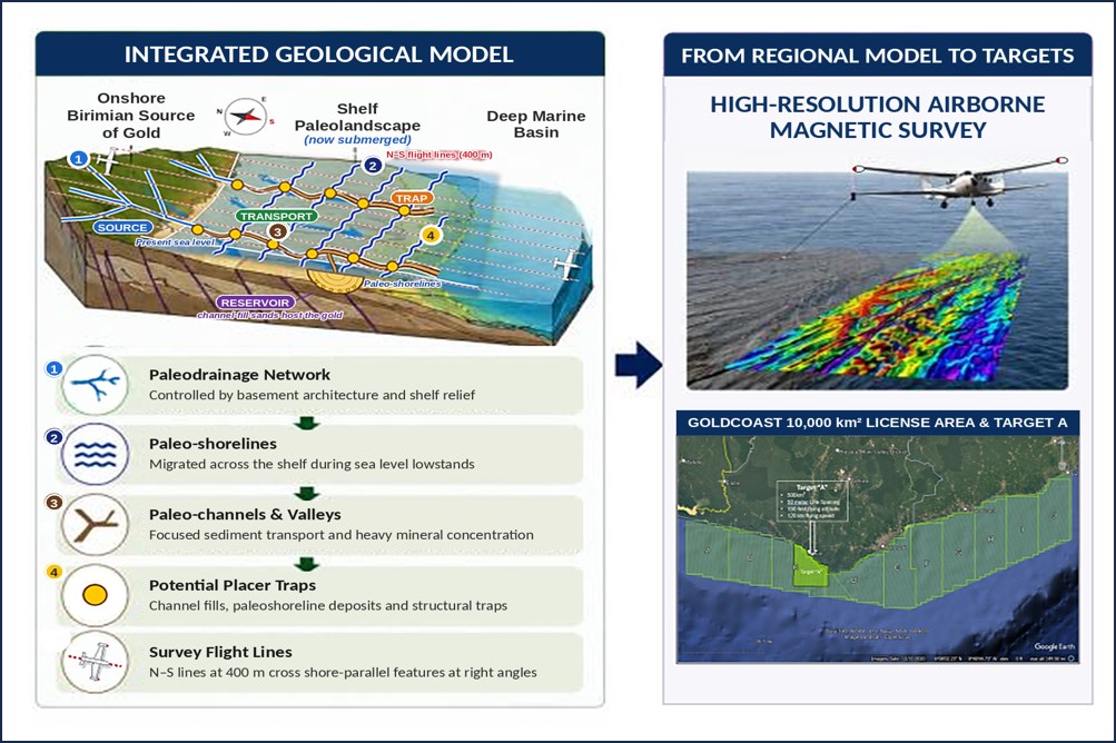
Figure 2: Integrated geological model and airborne magnetic survey covering the 10,000 km² license area and the 500 km² Target A infill area. Conceptual model; the shelf paleolandscape, formed when sea level was lower, is now submerged. Features shown schematically. Source: AiGeo.
To view an enhanced version of this graphic, please visit:
https://images.newsfilecorp.com/files/12162/321295_6f5eff5d54fc080b_002full.jpg
The data was interpreted by AI GeoIntelligence Corporation ("AiGeo") of Denver, Colorado. The survey was designed to identify concentrations of magnetic heavy minerals, such as magnetite and ilmenite, which commonly accompany placer gold. These minerals are expected to have accumulated in paleo-channels and other trap settings on the shelf, including drowned beach sands, shoreline scarps and ridges. High-resolution airborne magnetics allow these accumulations to be mapped, and the resulting offshore placer gold targets to be identified, evaluated and prioritized.
The regional survey was flown on north-south lines at 400-meter spacing, perpendicular to the coastline. This orientation is optimal for resolving features that trend parallel to the coast, including reworked beach sands formed during repeated marine transgression cycles, and paleo-scarps. It is less effective at resolving paleo-river channels, which trend perpendicular to the coast and parallel to the flight lines.
To address this, a second survey of approximately 500 km² has been flown over Target A, at the mouth of the Ankobra River, on east-west lines at 50-meter spacing. Crossing the paleo-river channels at right angles is designed to enhance their detection. This data is being interpreted, and results will be reported in a separate press release. Similar infill surveys, on east-west flight lines are contemplated over the Pra and Tano river mouths, in due course.
Geological Setting
Ghana, formerly known as the "Gold Coast," is Africa's largest gold producer and the only place on Earth where such a rich concentration of gold mineralization lies so close to the coast. Much of its gold endowment is hosted in Paleoproterozoic Birimian greenstone belts that extend to the coastline. Over millions of years of tropical weathering and erosion, an estimated 400 to 600 vertical metres of oxidized, gold-bearing rock has been eroded from these belts. The Tano, Ankobra and Pra river systems and their tributaries carried this material as bedload onto Ghana's shallow, low-gradient continental shelf.
This process intensified around the Last Glacial Maximum (LGM), approximately 20,000 years ago, and during the subsequent transition into the warmer Holocene, the current geological epoch. Lower sea levels during the LGM allowed high-energy rivers to rework and deposit substantial quantities of gold-bearing alluvial bedload across the exposed shelf. As global sea levels then rose by more than 100 metres, Ghana's coastline migrated approximately 30 to 50 kilometres inland to its present position, drowning these potential deposits.
Gold and other heavy minerals concentrate where transport energy decreases. On the shelf, the principal concentrating environments are paleo-river channels incised during periods of lower sea level, beach and shoreface sands reworked during successive marine transgressions, and structural and geomorphic traps such as bedrock scarps and basement highs.
Key Targets Identified
Block 1: Tano-Ankobra Source-to-Sink System
Block 1 covers the western portion of the license area, offshore of the Tano and Ankobra Rivers. The interpretation defines the four elements of a placer system as follows:
Source / Charge: The Tano and Ankobra river systems supply sediment from onshore gold-bearing Birimian terranes. Nearshore Birimian-affinity basement, interpreted to continue offshore, provides an additional local source.
Sink / Transport: Sediment is transported predominantly west to east along the shelf by longshore currents, with localized delivery through the Tano and Ankobra paleo-drainage systems.
Trap Geometries: Fault-controlled basement scarps, incised paleo-channels, shelf-edge structures, and structural and geomorphic traps, including buttress traps.
Reservoir: Interpreted zones of sediment accommodation and channel fill capable of hosting placer-bearing sediments. Their geometry and sediment character are not yet directly constrained at the current survey line spacing.
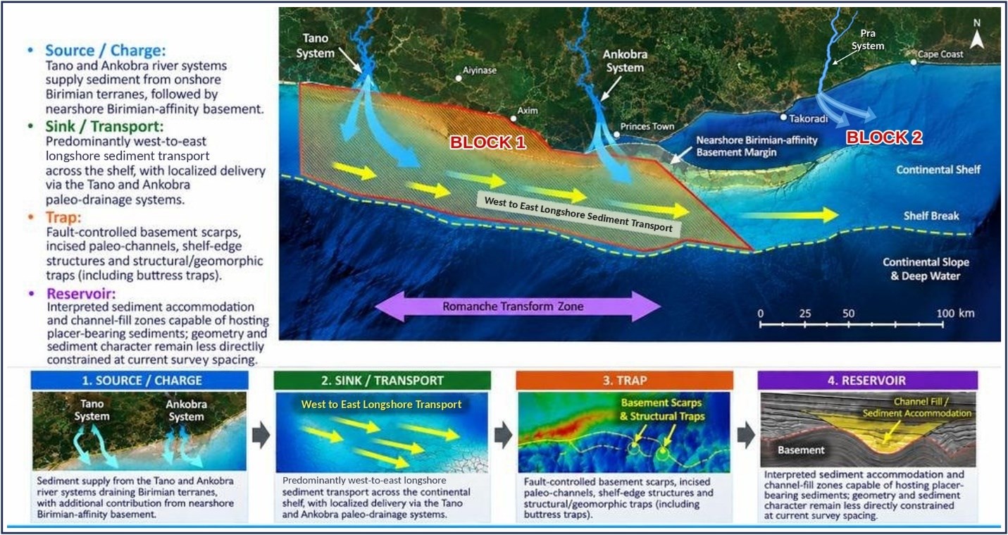
Figure 3: Block 1, Tano-Ankobra source-to-sink system, showing sediment supply, longshore transport, trap types and reservoir elements. Source: AiGeo.
To view an enhanced version of this graphic, please visit:
https://images.newsfilecorp.com/files/12162/321295_6f5eff5d54fc080b_003full.jpg
Block 2: Pra-Eastern Rivers Source-to-Sink System
Block 2 covers the eastern portion of the license area, from Akwidaa eastward beyond Cape Coast to Winneba. Sediment supply is dominated by the Pra River, with additional input from smaller rivers to the east and from nearshore Birimian-affinity basement. Sediment is transported west to east along the shelf and is interpreted to be trapped against three fault-bounded continental basement highs and associated shelf-edge and mid-shelf scarps.
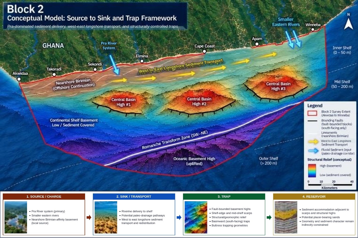
Figure 4: Block 2, Pra River and eastern river systems, conceptual source-to-sink and trap framework. Source: AiGeo.
To view an enhanced version of this graphic, please visit:
https://images.newsfilecorp.com/files/12162/321295_6f5eff5d54fc080b_004full.jpg
Structural Framework: Key features interpreted from the Block 2 data include an offshore continuation of the Birimian basement margin, three prominent fault-bounded continental basement highs, a dominant west-east structural grain, and the Romanche Transform Zone, a first-order structural boundary influencing shelf-edge segmentation.
Paleo-drainage corridors: Potential nearshore paleo-drainage corridors have been identified from the measured inline magnetic gradient. These corridors are strongest proximal to the Pra River and the smaller eastern river systems. They represent interpreted pathways by which river-borne, gold-bearing sediment was delivered across the shelf during periods of lower sea level.
Pra River paleo-shoreline target: A shore-parallel (southwest-northeast) belt of stepped Birimian basement ridges has been identified at the mouth of the Pra River. It is interpreted as a series of transgressive paleo-shorelines drowned as sea level rose approximately 120 meters following the Last Glacial Maximum, approximately 20,000 years ago. The oldest shorelines lie furthest seaward and the youngest closest to the present coast. Beach and shoreface reworking at each former shoreline are a recognized mechanism for concentrating heavy minerals, including magnetite, ilmenite, rutile, zircon and gold. The Pra River mouth is interpreted as the area of greatest sediment supply in Block 2.
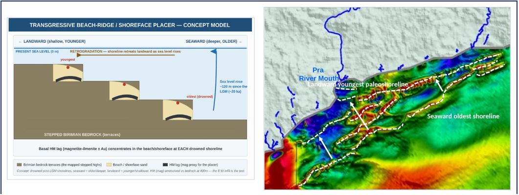
Figure 5 (left): Concept model. As sea level rose, the shoreline stepped landward, and heavy minerals concentrated at the base of each drowned beach. Source: AiGeo.
Figure 6 (right): Interpreted drowned shorelines (dashed lines) offshore of the Pra River mouth, from the oldest shoreline furthest seaward to the youngest closest to land. Source: AiGeo.
To view an enhanced version of this graphic, please visit:
https://images.newsfilecorp.com/files/12162/321295_goldcoast.jpg
This target is at a conceptual stage. At the current 400-meter line spacing, heavy-mineral sands cannot be distinguished from the underlying Birimian bedrock. The planned 50-meter east-west infill survey is designed to enhance resolution, test and (ideally) validate the conceptual target.
Strategic Next Steps
Targeted airborne infill surveys
GoldCoast is evaluating the merits of an infill survey of approximately 3,000 km² over the nearshore Pra River area. The area covers the Pra River mouth, the paleo-shoreline target and adjacent scarp targets. The survey is designed as follows:
Design: shore-parallel east-west flight lines at 50-meter spacing.
Rationale: east-west lines cross the interpreted paleo-drainage corridors at right angles, and 50-meter spacing is designed to resolve thin heavy-mineral (magnetite-ilmenite) sands not resolvable at 400-meter flight line spacing.
Supporting evidence: a prominent magnetic low at the Pra River mouth is interpreted as a major depocenter (an area of greatest sediment build-up) and a structural focus, independently supporting the proposed infill area.
Objective: to resolve the reservoir element across the target cluster and further define the paleo-shoreline and paleo-drainage targets.
Phase II: Integrated seaborne marine geophysics and sediment sampling
Following the infill surveys, the Company plans an integrated marine program to advance the airborne targets to sample-validated prospects. The program comprises:
Multibeam bathymetry: high-resolution seafloor morphology, including shoreline ridges, scarps and channels.
Side-scan sonar: seabed texture, exposed or sub-cropping features, sand bodies and channel margins.
Sub-bottom (2D chirp) seismic profiling: Holocene sediment thickness, buried channels and paleo-surfaces.
Vibracore and grab sampling: sediment lithology, grain size, heavy-mineral content, mineralogy and gold assays.
GoldCoast will combine the existing airborne magnetic data with new seismic data, avoiding the cost of a repeat survey, to build a 3D model of the seabed geology. This will identify drill-ready targets, which the Company will re-rank as each new dataset arrives so that capital goes to the strongest targets first.
Qualified Person
The technical information in this news release has been reviewed and approved by Sam Torkono, P.Geo., an independent Qualified Person as defined by National Instrument 43-101.
About GoldCoast Resource Corp.
GoldCoast Resource Corp. (CSE: GCR) (OTC: GCRFF) (FSE: EKW) is a Canadian mineral exploration company focused on offshore gold exploration in Ghana, Africa's largest gold-producing country. The Company holds a district-scale, 10,000 km² package of reconnaissance licenses covering approximately 53% of Ghana's offshore coastline - the only place on Earth where three major rivers, carrying gold-rich bedload eroded from gold belts over interglacial periods, converge on a shallow continental shelf. The offshore recovery of minerals from unconsolidated marine sediments is an established industry worldwide, with long-running precedents including Debmarine Namibia's marine diamond operations, PT Timah's offshore tin operations in Indonesia, and the United Kingdom's Crown Estate marine aggregates sector.
Additional information about GoldCoast Resource Corp. is available at goldcoastresource.com and on the Company's SEDAR+ profile at www.sedarplus.ca.
ON BEHALF OF THE BOARD OF GOLDCOAST RESOURCE CORP.
Michael Nikiforuk
Founder, CEO & Director
CONTACT INFORMATION
Tel: (416) 449-3996
Email: [email protected]
X: @GoldCoast_R
Connect with GoldCoast Resource Corp:
Email | Website | LinkedIn | X | YouTube | LinkTree
To register for investor updates please visit: goldcoastresource.com
CSE: GCR | OTC: GCRFF | FSE: EKW
Cautionary Note Regarding Forward-Looking Information
This press release includes "forward looking statements", within the meaning of applicable securities legislation, which are based on the opinions and estimates of management and are subject to a variety of risks and uncertainties and other factors that could cause actual events or results to differ materially from those projected in the forward looking statements. Forward-looking statements are often, but not always, identified by the use of words such as "seek", "anticipate", "budget", "plan", "continue", "estimate", "expect", "forecast", "may", "will", "project", "predict", "potential", "targeting", "intend", "could", "might", "should", "believe" and similar words suggesting future outcomes or statements regarding an outlook. Such risks and uncertainties include, but are not limited to, risks associated with the mining industry (including operational risks in exploration development and production; delays or changes in plans with respect to exploration or development projects or capital expenditures; the uncertainties involved in the discovery and delineation of mineral deposits, resources or reserves; the uncertainty of resource and reserve estimates and the ability to economically exploit resources and reserves; the uncertainty of estimates and projections in relation to production, costs and expenses; the uncertainty surrounding the ability of the Company to obtain all permits, consents or authorizations required for its operations and activities; and health and safety and environmental risks), the risk of commodity price and foreign exchange rate fluctuations, the ability of the Company to fund the capital and operating expenses necessary to achieve the business objectives of the Company, the uncertainty associated with commercial negotiations and negotiating with foreign governments and risks associated with international business activities, as well as those risks described in public disclosure documents filed by the Company. Due to the risks, uncertainties and assumptions inherent in forward-looking statements, prospective investors in securities of the Company should not place undue reliance on these forward-looking statements.
Statements in relation to "resources" and "reserves" are deemed to be forward-looking statements, as they involve the implied assessment, based on certain estimates and assumptions, that the reserves described can be profitably produced in the future.
Readers are cautioned that the foregoing lists of risks, uncertainties and other factors are not exhaustive. The forward-looking statements contained in this [press release] are made as of the date hereof and the Company undertakes no obligation to update publicly or revise any forward-looking statements contained in this press release or in any other documents filed with Canadian securities regulatory authorities, whether as a result of new information, future events or otherwise, except in accordance with applicable securities laws. The forward-looking statements contained in this press release are expressly qualified by this cautionary statement.
Neither the CSE nor its Market Regulator accepts responsibility for the adequacy or accuracy of this press release.

To view the source version of this press release, please visit https://www.newsfilecorp.com/release/321295
Serious News for Serious Traders! Try StreetInsider.com Premium Free!
You May Also Be Interested In
- Trican Reports Third Quarter Results for 2026 and Declares Quarterly Dividend
- National Research Corporation (NRC) Reports In-Line Q3 EPS
- Caring Brands (CABR) files for 24.51M share offering by selling stockholders
Create E-mail Alert Related Categories
Newsfile, Press ReleasesRelated Entities
Maynard Um, Mark Zuckerberg, ARKSign up for StreetInsider Free!
Receive full access to all new and archived articles, unlimited portfolio tracking, e-mail alerts, custom newswires and RSS feeds - and more!
